Contents:
He tiro whānui: Te whakamahere i ō tātou tauwāhi
An overview: Planning our places
We are creating a plan that will help us set a vision for the future of the Whakatāne, Kawerau and Ōpōtiki Districts within the rohe of the iwi and hapū of Eastern Bay of Plenty in the wider Bay of Plenty Region.
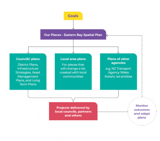
Our Places – Eastern Bay Spatial Plan will set out where the Eastern Bay of Plenty wants to head and provide a roadmap, or spatial plan, for how to get there.
Our Places isn’t finalised because we want to hear from you first. This is your chance to influence how future generations will experience the Eastern Bay.
What is a Spatial Plan?
Whakatāne, Kawerau, and Ōpōtiki District Councils are working with iwi, government agencies and Toi Moana Bay of Plenty Regional Council to create a spatial plan that will shape our region’s future.
A spatial plan is about how we (and future generations) want to live, work and play in the future Eastern Bay. It’s about providing safe places for people to live, supporting the local economy, adapting to climate change and protecting our environment – ultimately, ensuring people and place can thrive.
Decision makers use spatial plans to come up with options for the future of spaces and places, for example:
- how towns might spread out (or up)
- where to build papakāinga
- where to build on the coast (and where not to)
- what infrastructure (such as pipes, parks, and roads) might be needed to support growing communities.
Why do we need a Spatial Plan?
Currently, there is a shortage of land for building new homes, and many of the existing houses are not fit for purpose.
As the population grows in the Eastern Bay, along with expanding the Putauaki Trust Industrial Zone, developing aquaculture and growing existing industries, we could need about 5,500 more homes by 2055.
Although more residential land is becoming available, it is not enough to meet short- or long-term demand.
The limited housing supply is restricting economic development in the Eastern Bay. Put simply, without enough homes, it’s hard for our economy to grow – where would any new workers live?
Development in the Eastern Bay is also limited by things like natural hazards, conservation land, productive farmland, and land ownership rules – all of which restrict where new growth and housing density can happen. Being among the most challenging areas for development in the country, these issues will only get harder with a changing climate.We need to explore potential areas across the Eastern Bay that can support population growth while unlocking economic opportunities.
This is where the spatial plan comes in: Our Places – Eastern Bay Spatial Plan will help local and national agencies that deliver infrastructure, housing development and other critical services (such as health and education) understand future priorities, resourcing and funding needs to support the Eastern Bay.
It will reflect collective aspirations for the sub-region, and be used to inform council Long Term Plan processes, District Plan changes, and government infrastructure investment decisions.
In short, it will provide a pathway towards 2055 and help us work better together to get there.
Kawerau District Council
- Kawerau District is expected to need approximately 650 additional homes over the next 30 years. There is sufficient infrastructure capacity within the urban residential area to support growth.
- Kawerau District covers 24km2 so has limited opportunities for greenfield residential development. Increasing housing in the district will mean intensification of the existing residential area.
- Kawerau’s housing and growth strategy commenced more than a decade ago, enabling some 170 new residential dwellings. This includes Stoneham Park, which will be critical in delivering housing. Future increases in housing will still be required to attract workers to live in the town.
- The Putauaki Trust Industrial Zone now has the potential to expand in the future, supported by two boundary reorganisations between Kawerau and Whakatāne District Councils, ensuring that Kawerau remains the prime location as the industrial centre of the Eastern Bay.
- There are also areas of residential zoned, Māori-owned land that could provide opportunities for papakāinga and Māori-led housing option

